by William B. Green and Eric
M. DeJong
California Institute of Technology, Jet Propulsion Laboratory
Editor's Note: In recent weeks we have all
been captivated by the images returning to earth from Mars. Here William
B. Green and Eric M. DeJong describe how images are created from thousands
of miles away. To learn more about JPL and NASA's space missions you can
visit http://www.jpl.nasa.gov.
Figure 1.
Caltech's Jet Propulsion Laboratory (JPL) has been processing digital image data returned from remote sensing instruments on spacecraft since the Mariner 4 spacecraft flew by Mars in 1964. Many of the digital image processing techniques now routinely used in desktop publishing and computer graphics systems were designed originally to process and enhance images returned from space. JPL, other NASA centers, universities, and the Department of Defense made significant contributions to the development of this technology. In the past fifteen years, sophisticated processing capabilities have been developed to support scientific analysis of remotely sensed imagery. The use of three-dimensional perspective rendering achieved by merging elevation data with two-dimensional sampled imagery has become a valuable tool for image interpretation and geological analysis. Animated sequences of rendered imagery provide dramatic, scientifically precise "fly-over" simulations that capture the public's attention while providing a visual aid to scientists attempting to understand the nature and evolution of the earth and other objects in the solar system. More recently, capabilities have been developed to support mission planning by integrating spacecraft models from Computer Aided Design (CAD) systems with remotely sensed imagery to enable visualization of mission scenarios for current and future deep space exploration missions. This article describes the basic methods used at JPL's Multimission Image Processing Laboratory (MIPL) and Digital Image Animation Laboratory (DIAL) to produce a variety of animation and visualization products from imagery returned by NASA spacecraft.
Figure 2.
Acquiring Image Data From Space
Figure 1 shows the flow of data for a typical planetary exploration mission.
Remote sensing data from instruments on the spacecraft are returned to
earth receiving stations in digital form, and transferred to data processing
facilities that acquire the data and convert individual telemetry segments
into scientific data records. The data processing paths for NASA earth
observation missions are similar. For imaging instruments, image data records
are created that contain the basic pixel data (decompressed if necessary)
plus additional information including engineering data (camera temperature,
voltages, etc.), navigation data (spacecraft location and orientation when
the image was acquired), ephemeris data (information regarding the positions
of planets, the sun, and other objects such as the moons orbiting other
planets when the image was acquired), and camera geometry (where was the
camera pointing, what was the view angle, etc.).
The engineering data is utilized to remove the camera signature from the
returned imagery and convert the data to physical units (e.g., brightness).
The geometry data is used in constructing various views of the surface
later in the animation process. The formation of these data records is
shown in the boxes labeled "real time" and "systematic".
Note that it is often necessary to construct image data records from telemetry
data acquired at different times or at different ground receiving stations.
Archival digital data products are produced at various stages of the processing
stream and preserved for long term scientific study. Specialized enhanced
products are also generated to support detailed scientific analysis, and
public information office (PIO) products are also generated for dissemination
to the press and made available via the Internet.
Figure 3.
Basic Image Rendering
Once the image data has been converted to physical units, and the geometry
is understood, it is possible to generate perspective view and animation
products. This was first done at JPL in the early 1980's by a team led
by Kevin Hussey. Hussey's team produced L.A. - the Movie, an animated
sequence that simulated a fly-over of Southern California utilizing multispectral
image data acquired by the Landsat earth orbiting spacecraft. The remotely
sensed imagery was rendered into perspective projections using digital
elevation data sets available for the area within a Landsat image. Figure
2 illustrates the basic process. The upper left image shows one band extracted
from the Landsat image. A segment from the image has been selected for
rendering, and the perspective viewpoint has been defined as shown by the
green and blue graphics overlay. The upper right image is a gray scale
representation of the elevation data available for the image segment, with
the same perspective viewpoint indicated. The elevation along the blue
path in these images is shown graphically in the lower left image. Once
the animation producer is satisfied with the viewpoint and perspective,
the scene is rendered in 3D perspective as shown in the lower right hand
image.
The scientist or animation director sketches out a desired flight path,
as shown in Figure 3. The flight path is defined by a set of "key
frames." Each key frame is characterized by a specific viewing geometry
and viewpoint, and software interpolates between key frames defined along
the flight path to render intermediate frames to produce the final animation.
The animator controls the simulated speed of the flyover by specifying
the number of frames to be interpolated between each key frame. Figure
4 shows one frame from the film L.A. - the Movie, showing the Rose
Bowl with JPL in the background against the San Gabriel mountains. The
vertical scale is exaggerated by a factor of 2.5 to show small scale features.
Figure 4.
Planetary And Earth Applications
Rendering and interpolation algorithms have been improved since the era
of L.A. - the Movie. In recent years, MIPL and DIAL have collaborated
to produce a variety of fly-over sequences of planetary and earth imagery.
Project scientists have found it invaluable to obtain three dimensional
perspective views of remote planets and their satellites. The use of stereo
imagery generally acquired by aircraft has been widespread in the geology
community for many years. A three dimensional view of the surface provides
analysis of surface features, the evolution of the surface, and the nature
of surface disturbances that are volcanic or seismic in origin. Three-dimensional
rendered animated imagery has become useful in planetary exploration for
the same reasons.
Figure 5 shows a perspective view of Maat Mons, a large volcano on Venus.
The Magellan mission mapped the surface of Venus using Synthetic Aperture
Radar (SAR) in the early 1990's. Elevation information was provided by
radar on board the spacecraft, from analysis of stereo image coverage of
the surface, and from data acquired by earlier missions to Venus. Surface
color has been incorporated into this image, based on limited radiometric
measurements obtained by a Russian lander spacecraft on Venus in the 1970's.
The Russian spacecraft was ultimately crushed by the atmospheric pressure,
but survived long enough to provide a limited sampling of surface color.
Figure 5.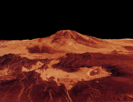
In the mid 1970's, two Viking landers and two
Viking orbiter spacecraft provided thousands of images of Mars from orbit
and from two separate landing sites. The orbital imagery provided stereo
coverage of significant portions of the Martian surface. Elevation computed
from stereo imagery enabled perspective rendering and animation of portions
of the Martian surface. Figure 6 shows a single three-dimensional image
produced in this manner.
The Space Shuttle has carried synthetic aperture radar systems on three
separate occasions, obtaining high resolution radar imagery of the earth's
surface. The third mission, referred to as SIR-C (Shuttle Imaging Radar
mission C) provided coverage of the Mammoth Mountain area of California
in 1995. Figure 7 shows a three-dimensional perspective view created from
SIR-C SAR images acquired by the radar system. SAR imagery requires different
interpretation than imagery acquired by a more conventional imaging system.
Brightness differences in SAR imagery represent differences in surface
texture and the orientation of surface features on the surface, rather
than the color or reflectance of the surface. Bright features are oriented
normal to the direction in which the radar signal travels, since the radar
will be reflected strongly from surfaces normal to the radar beam. Dark
features are generally more aligned with the direction of radar signal
travel. Differing textures will also reflect the radar beam differently.
This is illustrated in Figure 8 which shows a false color perspective projection
of the same area. Here, false color is used as an interpretive aid to highlight
differences in surface feature orientation and surface texture. This false
color rendered representation provides an extremely useful tool for scientific
interpretation.

Figure 6.
Mission Planning
Visualization and animation are also useful for mission planning and mission
operations. It is possible to incorporate CAD models of spacecraft with
remotely sensed imagery in animations to illustrate spacecraft trajectories
and data acquisition strategies. Animation displays are also provided to
explain planned mission events during flight operations to members of the
press and the public via the news media. Figure 9 shows one frame extracted
from an animation of the Galileo spacecraft approach to Jupiter in December
1995. The spacecraft model was rendered from a CAD model of the spacecraft
obtained from the spacecraft design team. The star background is produced
from a standard reference star catalog, and the Jupiter image was acquired
by the Hubble space telescope. The spacecraft trajectory and planet motion
models were derived for the animation from mission navigation files and
command sequence files.
Figure 7.
A Growing Roll
Visualization and animation are becoming increasingly important tools in
planetary exploration. High speed computing equipment and increasingly
sophisticated software systems are making it possible to produce the types
of products shown in this article on rapid time scales. These products
are extremely useful in science analysis during flight operations, and
are beginning to play an increasingly important role in supporting future
mission planning and data acquisition strategies.
Acknowledgements
The authors wish to acknowledge the contributions of the following individuals
for their contribution to the figures: Raymond J. Bambery, Jeffrey R. Hall,
Shigeru Suzuki, Randy Kirk, Alfred McEwen, Myche McAuley, Paul Andres.
In addition, the work of many other individuals within JPL's Science Data
Processing Systems Section, and many individuals supporting JPL's flight
projects, makes it possible to acquire the data sets used to produce the
types of products shown here, and their effort is hereby acknowledged.
The work described in this paper was carried out at the Jet Propulsion
Laboratory/ California Institute of Technology under a contract with the
National Aeronautics and Space Administration.
Figure 8.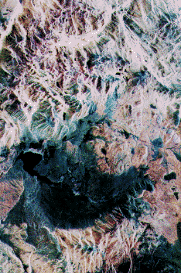
William B. Green is Manager of the Science
Data Processing Systems Section at CalTech's Jet Propulsion Laboratory.
He has responsibility for design, development, implementation and operation
of ground based systems used to process science instrument data returned
by NASA's planetary and earth observation spacecraft. Current activities
include processing imaging and multispectral data returned by the Galileo
spacecraft now in orbit around Jupiter, preparations for processing images
of Saturn and its moons from the Cassini mission to be launched in late
1997, and for processing of stereoscopic images of the surface of Mars
to be acquired by the Mars Pathfinder lander in July 1997. The Section
is also involved in supporting flight and ground software development and
development of data reduction systems for a variety of earth remote sensing
instruments to be flown as part of NASA's Mission to Planet Earth. The
Section produces a variety of digital, film and video products; these include
CD-ROM and photoproduct archival databases, and animations and "fly-over"
sequences of planets and other solar system objects. The Section also develops
and maintains a variety of Internet image data base browsers, providing
public access to large planetary image data bases resident at JPL.
He is the author of two textbooks, Digital
Image Processing--A Systems Approach and Introduction to Electronic
Document Management Systems, and numerous technical papers. He has taught
image processing at Harvard University, California State University at
Northridge, and George Washington University. Mr. Green is a Senior Member
of IEEE.

Figure 9.
Dr. Eric M. DeJong is a Planetary Scientist with the Earth and Space Sciences Division of the NASA Jet Propulsion Laboratory and a Visiting Associate at Caltech. His major research is the creation of image and animation products for NASA Space & Earth Science missions. He led the visualization efforts for the Voyager Neptune , Magellan Venus, Galileo Earth missions and Hubble Space Telescope Saturn & SL9 observations. He has participated in the scientific analysis of observations from these missions. He is the principal investigator for the Solar System Visualization (SSV) Project, which was selected by NASA as one of three NASA science projects featured at the World Space Congress for the International Space Year. He, and his team created planetary image sequences for the IMAX films Journey to the Planets, Destiny in Space and L5: First City in Space.

William B. Green.
Table of Contents
Feedback?
Past Issues
![]()
![]()
![]()
![]()
![]()
![]()
[about | help
| home | info@awn.com
| mail | register]
© 1997 Animation World Network